NEWS RELEASE
PHOENIX — An ongoing tamarisk removal project by the Arizona Game and Fish Department (AZGFD) and its partners in the Lower Gila River Collaborative (LGRC) is aiming to restore the river’s riparian corridor, lowering fire and flood risk and allowing native plants, wildlife and outdoor recreation to thrive.
Introduced to the lower Gila River in the mid-1800s to combat erosion and stabilize riverbanks, tamarisk, also known as salt cedar, soon created more problems than it solved.
“The lower Gila quickly became overtaken with invasive tamarisk encroachment, and now the vast majority of the Lower Gila River has become dense monocultures of tamarisk which provide minimal opportunities for wildlife and public recreation,” said Bobby Lamoureux, AZGFD’s habitat, evaluation and lands program manager for region 6.
Dense stands of tamarisk altered water flow in the river, stifled the growth of native species, and caused flooding in nearby farms and developments—many of which were historically outside the floodplain and unprepared for high water events.
Arizona isn’t alone in battling tamarisk. The invasive plant has become a problem across much of the Southwest, especially in arid and semi-arid regions where it has overtaken river corridors, wetlands and riparian zones.
“In 2001, six states released an insect that feeds on the tamarisk, called the northern tamarisk beetle, in an attempt to control the invasive plant species,” said Lamoureux.
While the beetles weren’t released in Arizona, they soon made their way here and began feeding on—and killing—large areas of tamarisk. Eating only on the leaves, the beetles leave behind dry, dead branches that are highly flammable.
“Even when alive, tamarisk burns hotter than native plants,” said Lamoureux. “But the dead, dense tamarisk branches are like matchsticks.”
In 2018, AZGFD joined with communities and other organizations to form the Lower Gila River Collaborative, with a shared goal: remove tamarisk and restore the river’s riparian corridor. But removing tamarisk is not an easy task.
“You have to use heavy equipment to rip it out, or utilize multiple applications of herbicide,” said Lamoureux. “And it’s able to grow back from even a small fragment, so we often follow up physical removal with herbicide or fire treatment.”
Even after removal, tamarisk continues to affect the areas where it was present. The plant pulls salt from the soil and releases it through its leaves, creating a highly saline environment over time that lingers following removal.
“We have to wait about a year after removal to begin planting native species,” said Lamoureux. “That’s how long it takes for the salt to be washed away and for the soil to return to a healthy state for plants like cottonwoods and willows.”
Once native plants are reestablished, the area is monitored for at least three years to treat any tamarisk regrowth.
Removing an invasive species at this scale is also an expensive prospect. Fortunately, one of the LGRC partners—the Department of Forestry and Fire Management—has provided a substantial portion of the funding for these efforts and assists with project planning and implementation.
“We currently have two active projects, with one completed and three more planned, all thanks to the funding provided by the Department of Forestry and Fire Management,” said Lamoureux.
AZGFD is involved in tamarisk removal projects throughout central and southern Arizona, including work at Robbins Butte, the Lower San Pedro River and other locations. But Lamoureux is particularly pleased with the department’s work on the Lower Gila River, along with partnering agencies’ work within the collaborative, with roughly 1,000 acres planned across all projects.
“I’m really proud of the amount of work we’ve completed on this stretch of the river,” said Lamoureux. “It’s great to see native vegetation coming back—and to see wildlife and outdoor recreationists have access to this river again.”
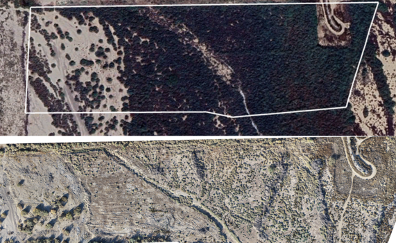
Top photo shows tamarisk invasion. Bottom photo is post tamarisk-removal, showing the reintroduction of native plants and open space for water to flow and wildlife and recreationists to access the area.